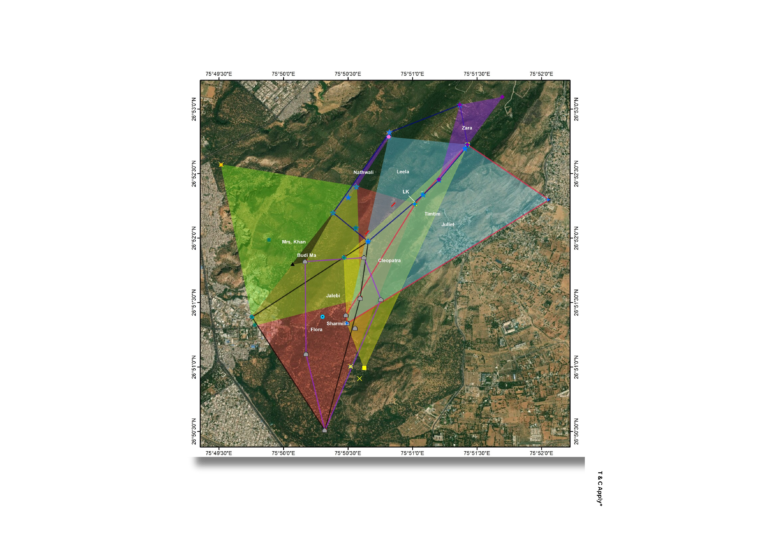
Home Range Mapping Home range mapping uses Field and spatial analysis to determine the movement patterns and territorial boundaries of wildlife species. This helps in understanding species behaviour, habitat use, and conservation planning. Track species movement and protect critical habitats—work with us for data-backed conservation mapping
Ecological Sustainability Index The Ecological Sustainability Index (ESI) integrates environmental, ecological, and anthropogenic indicators to assess the long-term viability of ecosystems. This index supports data-driven environmental planning and policy formulation. Measure what matters—use our ESI framework to guide sustainable ecosystem management.
Habitat Suitability Habitat suitability analysis uses GIS and ecological parameters to identify optimal zones for specific species. It supports biodiversity conservation, relocation planning, and environmental impact assessments. Identify where species thrive—partner with us for targeted habitat analysis.
Wildlife Conflict Mapping Human–wildlife conflict zones are mapped using incident data, species movement, and land-use patterns to visualize areas of overlap. This enables targeted conflict mitigation strategies and community engagement. Reduce conflicts and protect lives—leverage spatial intelligence for coexistence.
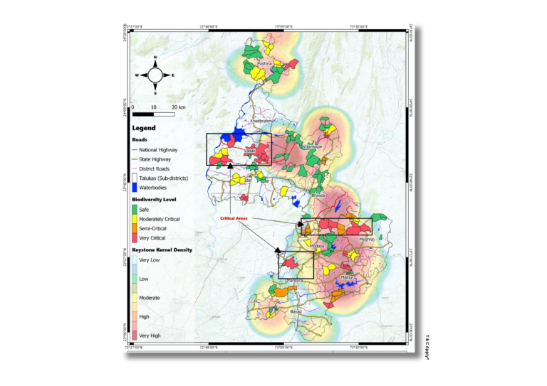
Biodiversity Mapping
Biodiversity patterns are mapped using on-the-ground observations of flora and fauna, integrated with habitat data and terrain features to reveal ecological richness and species distribution. This supports data-driven conservation planning and habitat management.
Turn observations into impact—map biodiversity for lasting change.
Home Range Mapping Home range mapping uses Field and spatial analysis to determine the movement patterns and territorial boundaries of wildlife species. This helps in understanding species behaviour, habitat use, and conservation planning. Track species movement and protect critical habitats—work with us for data-backed conservation mapping
Ecological Sustainability Index The Ecological Sustainability Index (ESI) integrates environmental, ecological, and anthropogenic indicators to assess the long-term viability of ecosystems. This index supports data-driven environmental planning and policy formulation. Measure what matters—use our ESI framework to guide sustainable ecosystem management.
Habitat Suitability Habitat suitability analysis uses GIS and ecological parameters to identify optimal zones for specific species. It supports biodiversity conservation, relocation planning, and environmental impact assessments. Identify where species thrive—partner with us for targeted habitat analysis.
Wildlife Conflict Mapping Human–wildlife conflict zones are mapped using incident data, species movement, and land-use patterns to visualize areas of overlap. This enables targeted conflict mitigation strategies and community engagement. Reduce conflicts and protect lives—leverage spatial intelligence for coexistence.
Biodiversity Mapping
Biodiversity patterns are mapped using on-the-ground observations of flora and fauna, integrated with habitat data and terrain features to reveal ecological richness and species distribution. This supports data-driven conservation planning and habitat management.
Turn observations into impact—map biodiversity for lasting change.