01
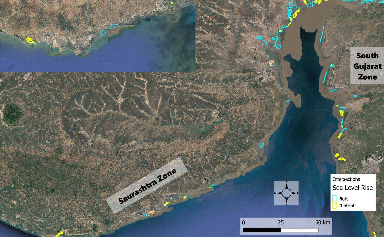
Mangrove Suitability Assessment
Category: Mangrove
- Conducted a GIS-based mangrove site suitability analysis along the Gujarat coastline to identify areas suitable for sustainable mangrove growth.
- Integrated multiple spatial and environmental parameters into a unified suitability framework to support objective site selection.
- Assessed historical trends, current environmental conditions, and future projected influences to ensure long-term planning relevance.
- Incorporated administrative boundaries to align outputs with regulatory and regional planning frameworks.
- Delivered suitability maps through an interactive GIS dashboard, enabling stakeholders to visualize, filter, and interpret results at multiple spatial scales for informed decision-making.
02
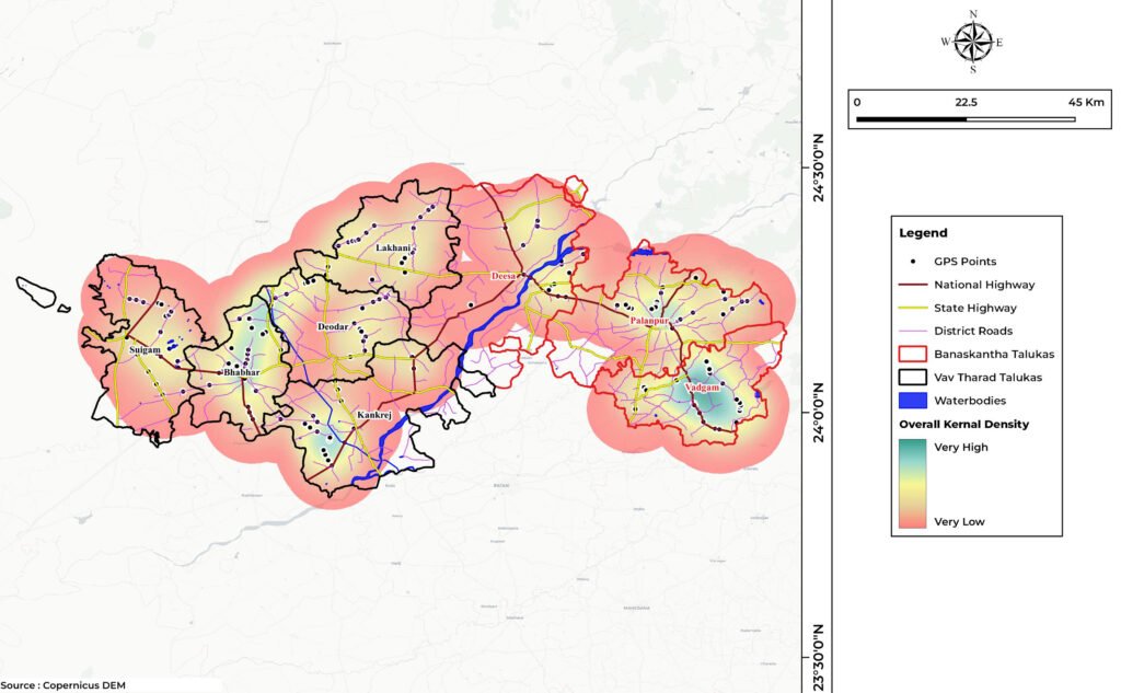
Ecological Profile of 8 Talukas
Banaskantha and Vav Tharad District
Category: Ecology
- Developed a comprehensive ecological profile for eight talukas by integrating multi-source geospatial datasets.
- Analysed hydrological systems, land conditions, terrain and slope variability, and geological and structural characteristics to capture regional environmental context.
- Mapped flora and fauna distribution to support biodiversity assessment and ecological understanding.
- Evaluated ecological sustainability to identify environmentally sensitive zones and conservation priority areas.
- Delivered outputs through an interactive Geoportal, enabling researchers, planners, and environmental managers to access, explore, and apply ecological insights for informed decision-making.
03
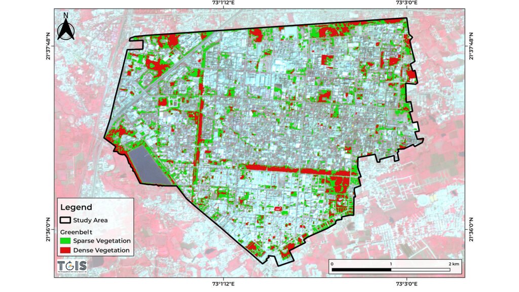
Greenbelt and Carbon Stock of Industry
Category: Carbon Stock
- Conducted a large-scale greenbelt assessment across an urban industrial area to evaluate the extent, distribution, and effectiveness of existing vegetative cover.
- Analysed the role of green infrastructure in supporting environmental quality within a high-intensity industrial setting.
- Estimated carbon stock associated with greenbelt areas to quantify their contribution to carbon storage and climate mitigation.
- Identified gaps and strengths in greenbelt coverage to support sustainable industrial development and compliance-oriented environmental planning.
- Delivered spatial insights to guide environmentally informed industrial planning and green infrastructure enhancement.
04
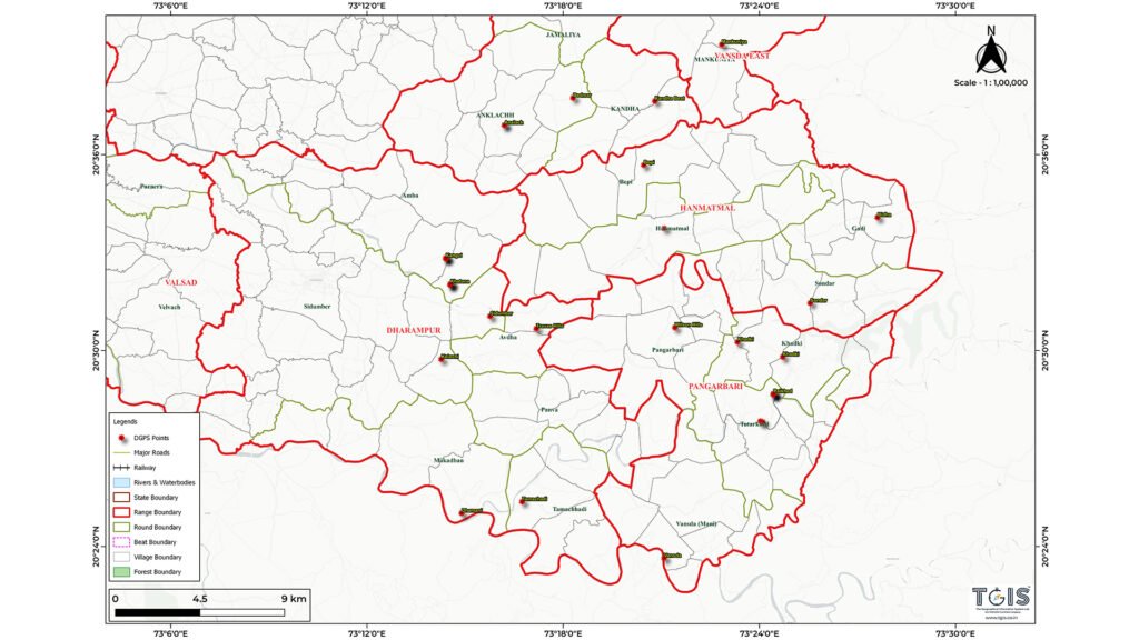
Forest Administration Mapping Valsad North Division
Category : Forest
- Carried out comprehensive forest administration mapping for the Valsad North Forest Division, covering ranges, rounds, and beat-level jurisdictions.
- Executed high-precision DGPS-based surveys to accurately delineate forest administrative boundaries on the ground.
- Developed a reliable spatial framework to enhance boundary clarity and reduce jurisdictional ambiguity.
- Supported forest planning, monitoring, and administrative record management through accurate and standardized geospatial datasets.
- Strengthened the integrity and reliability of spatial data used for forest governance and long-term forest management.
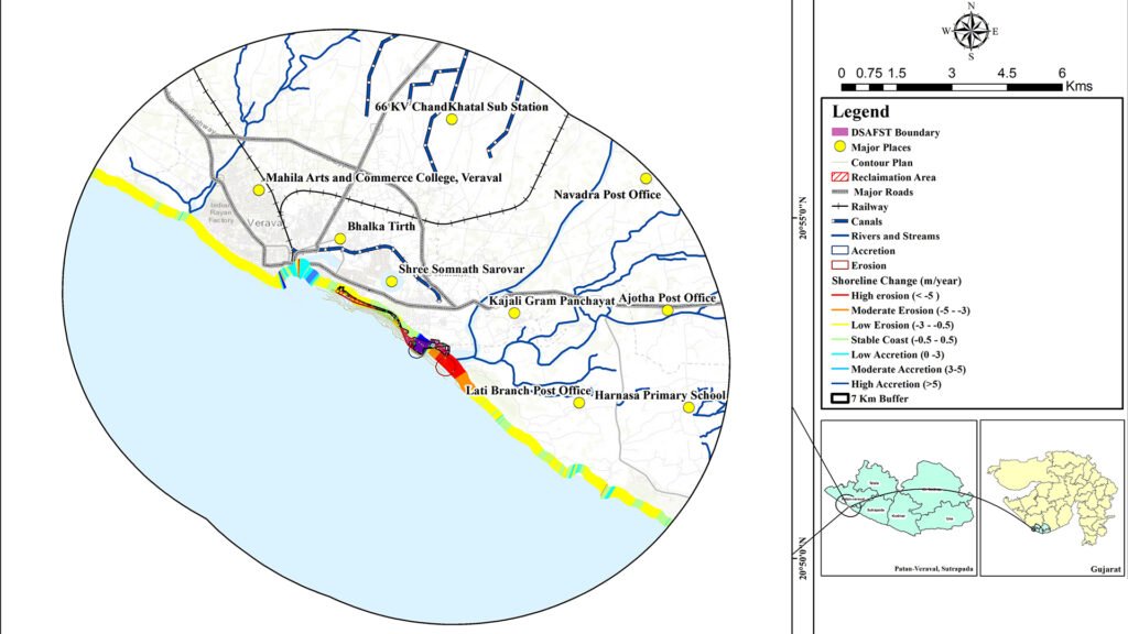
05
Impact Assessment with Shoreline Change Prediction
Category: Coastal Study
- Conducted an Environmental Impact Assessment integrated with shoreline change analysis.
- Analysed 30 years of historical shoreline data to quantify erosion and accretion trends up to the present.
- Assessed future shoreline change risk based on observed trends and projected scenarios.
- Evaluated the impact of reclamation structures on natural shoreline dynamics.
- Delivered predictive shoreline insights to support risk-informed coastal planning and regulatory decision-making.
06
Varsoda
Category: Landscaping
High-Resolution LiDAR-Based Terrain and Environmental Assessment
- Conducted high-resolution LiDAR surveys to generate DEMs for detailed terrain characterization.
- Utilized LiDAR-derived elevation data for Environmental Impact Assessment and land use. land cover classification.
- Generated elevation profiles to support terrain and infrastructure analysis.
- Performed hydrological modelling to evaluate surface runoff behaviour and drainage patterns.
- Delivered high-accuracy spatial outputs to support impact assessment, planning, and drainage management decisions.
01
Mangrove Suitability Assessment
Category: Mangrove
- Conducted a GIS-based mangrove site suitability analysis along the Gujarat coastline to identify areas suitable for sustainable mangrove growth.
- Integrated multiple spatial and environmental parameters into a unified suitability framework to support objective site selection.
- Assessed historical trends, current environmental conditions, and future projected influences to ensure long-term planning relevance.
- Incorporated administrative boundaries to align outputs with regulatory and regional planning frameworks.
- Delivered suitability maps through an interactive GIS dashboard, enabling stakeholders to visualize, filter, and interpret results at multiple spatial scales for informed decision-making.
02
Ecological Profile of 8 Talukas
Banaskantha and Vav Tharad District
Category: Ecology
- Developed a comprehensive ecological profile for eight talukas by integrating multi-source geospatial datasets.
- Analysed hydrological systems, land conditions, terrain and slope variability, and geological and structural characteristics to capture regional environmental context.
- Mapped flora and fauna distribution to support biodiversity assessment and ecological understanding.
- Evaluated ecological sustainability to identify environmentally sensitive zones and conservation priority areas.
- Delivered outputs through an interactive Geoportal, enabling researchers, planners, and environmental managers to access, explore, and apply ecological insights for informed decision-making.
03
Greenbelt and Carbon Stock of Industry
Category: Carbon Stock
- Conducted a large-scale greenbelt assessment across an urban industrial area to evaluate the extent, distribution, and effectiveness of existing vegetative cover.
- Analysed the role of green infrastructure in supporting environmental quality within a high-intensity industrial setting.
- Estimated carbon stock associated with greenbelt areas to quantify their contribution to carbon storage and climate mitigation.
- Identified gaps and strengths in greenbelt coverage to support sustainable industrial development and compliance-oriented environmental planning.
- Delivered spatial insights to guide environmentally informed industrial planning and green infrastructure enhancement.
04
Forest Administration Mapping Valsad North Division
Category : Forest
- Carried out comprehensive forest administration mapping for the Valsad North Forest Division, covering ranges, rounds, and beat-level jurisdictions.
- Executed high-precision DGPS-based surveys to accurately delineate forest administrative boundaries on the ground.
- Developed a reliable spatial framework to enhance boundary clarity and reduce jurisdictional ambiguity.
- Supported forest planning, monitoring, and administrative record management through accurate and standardized geospatial datasets.
- Strengthened the integrity and reliability of spatial data used for forest governance and long-term forest management.
05
Impact Assessment with Shoreline Change Prediction
Category: Coastal Study
- Conducted an Environmental Impact Assessment integrated with shoreline change analysis.
- Analysed 30 years of historical shoreline data to quantify erosion and accretion trends up to the present.
- Assessed future shoreline change risk based on observed trends and projected scenarios.
- Evaluated the impact of reclamation structures on natural shoreline dynamics.
- Delivered predictive shoreline insights to support risk-informed coastal planning and regulatory decision-making.
06
Varsoda
Category: Landscaping
High-Resolution LiDAR-Based Terrain and Environmental Assessment
- Conducted high-resolution LiDAR surveys to generate DEMs for detailed terrain characterization.
- Utilized LiDAR-derived elevation data for Environmental Impact Assessment and land use. land cover classification.
- Generated elevation profiles to support terrain and infrastructure analysis.
- Performed hydrological modelling to evaluate surface runoff behaviour and drainage patterns.
- Delivered high-accuracy spatial outputs to support impact assessment, planning, and drainage management decisions.
Would you like to start a project together? alongside us? with us?